


FSWidgets QuickPlan

توضیحات FSWidgets QuickPlan
FSWidgets QuickPlan is a visual touch enabled flight planner that makes it easy to generate flight plans in native FSX, FS2004 or X-Plane formats.
For the folk commenting saying they didn't know it was a DEMO, we don't know how to make this any clearer. This is a DEMO only, the full version can be purchased from our site.
*** Please note, this is a DEMO VERSION ONLY ***
Demo is limited to the San Francisco (KSFO) region only, it is fully functional but will operate only in that region. For purchase details please visit our site and our store at http://fswidgets.com. We provide this demo to give you the opportunity to test QuickPlan and ensure you are happy with its features. Should you decide to purchase, you will receive a key that will unlock the demo version.
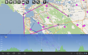
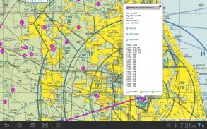
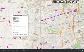
The entire route is generated visually, by tapping the map to add the departure airport, intermediate waypoints and arrival airport in the same order that you intend flying the plan.
Flight plans are saved and loaded using the SD card on the phone or tablet. Plans can be exported using any normal file browser on the Android device or by using standard Windows or Mac file management tools.
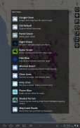
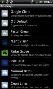
QuickPlan utilises a new mapping engine and includes 12 world-wide map styles and has support for FSWidgets Cloud Based Aero Chart products (free Cuba/Puerto Rico WAC Cloud Based Chart included) and the FSWidgets Cloud Based World Nav Data product (Free KSFO - San Francisco Bay area Nav Data included).
Main Features:
Supports tablets, hi-resolution phones, standard and low-end screens and devices
Generates native FSX (.pln), FS2004 (.pln) and X-Plane (.fms) format flight plans
Saves flight plans to the SD card, can be exported/imported
Flight plans can be exported via USB connection or SD card
Terrain profile display using the FSWidgets terrain engine
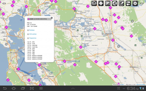
Search for airport by ICAO identifier
Map powered by CloudMade Leaflet API (using OpenStreetMap data)
Includes 14 world-wide maps styles
Supports FSWidgets Cloud Based Aero Charts
Free Cuba/Puerto Rico WAC Cloud Based Chart included
Supports FSWidgets Cloud Based World Nav Data
Free KSFO (San Francisco Bay) area Nav Data included
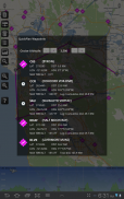
World-wide Metar and TAF Data icons
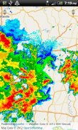
US Nexrad (Next-Gen Radar) Data
QuickPlan can be used in Freeform Mode, Advanced Mode, or a combination of both:
Freeform Mode:
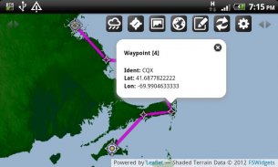
Simply tap anywhere on the map and QuickPlan will allow you to add it as a generic waypoint. VFR pilots often use towns, lakes and other unique geographic features and with QuickPlan you can add any geographical location shown on the base map. Plans created this way label the waypoints automatically with generic names (e.g. DEP, WP1, WP2, ARR).
If desired, the entire route from departure to arrival can be created without reference to any navigational aids or official airports. This is handy for bush pilots who often use unlicensed airfields and small landing strips (or seaplane landing areas). Helicopter pilots can also quickly create plans that depart from off-airport locations like building rooftops or land on a road.
Advanced Mode:
If you own the FSWidgets Cloud Based World Nav Data product you can create more advanced flight plans by tapping on any of the icons displayed on the map to add them as waypoints - airports, VOR's, NDB's and intersections (data for the KSFO area is included free). Plans created this way label the waypoints automatically with airport and navigational aid identifiers taken from the Nav Data (e.g. KSFO, OSI, LV, FABLA).
Who we are:
FSWidgets is a software development team based in Australia, specializing in add-ons for Microsoft Flight Simulator (Windows) and Laminar Research X-Plane (Windows, Mac, Linux). Both of its founding members have extensive experience in creating award-winning add-ons for flight simulators and have been active in the simming community for well over a decade.
</div> <div jsname="WJz9Hc" style="display:none">FSWidgets QuickPlan is een visuele touch-enabled vlucht planner die het gemakkelijk maakt om vliegplannen in inheemse FSX, FS2004 of X-Plane formaten te genereren.
Voor de folk commentaar zeggen dat ze niet wisten dat het een DEMO, weten we niet hoe dit duidelijker te maken. Dit is een DEMO alleen, kan de volledige versie worden gekocht van onze site.
*** Let op, dit is een DEMO VERSIE ***
Demo is beperkt tot de San Francisco (KSFO) regio alleen, het is volledig functioneel, maar alleen in die regio actief zijn. Voor aankoop informatie kunt u terecht op onze site en onze winkel op http://fswidgets.com. Wij bieden deze demo om u de gelegenheid te geven QuickPlan testen en ervoor zorgen dat u tevreden bent met de functies zijn. Mocht u besluiten om te kopen, zal je een sleutel die de demo-versie zal openen ontvangen.
De gehele route wordt visueel gegenereerd, door de kaart te tikken om de luchthaven van vertrek, tussentijdse waypoints en de luchthaven aankomst voegen in dezelfde volgorde die u van plan vliegt het plan.
Vliegplannen worden opgeslagen en geladen met behulp van de SD-kaart op de telefoon of tablet. Plannen kunnen worden uitgevoerd met behulp van een normale file browser op het Android-apparaat of door het gebruik van standaard Windows-of Mac-bestandssysteem management tools.
QuickPlan maakt gebruik van een nieuwe mapping engine en bevat 12 wereldwijde kaart stijlen en heeft ondersteuning voor FSWidgets Cloud Based Aero Grafiek producten (Gratis Cuba / Puerto Rico WAC Cloud Based Grafiek inbegrepen) en de FSWidgets Cloud Based Wereld Nav Data product (Gratis KSFO - San Francisco Bay gebied Nav Data inbegrepen).
Belangrijkste kenmerken:
Ondersteunt tabletten, hi-resolutie telefoons, standaard en low-end schermen en apparaten
Genereert inheemse FSX (. PLN), FS2004 (. PLN) en X-Plane (. FMS) formaat vliegplannen
Slaat vliegplannen naar de SD-kaart, geëxporteerd / geïmporteerd kunnen worden
Vliegplannen kan via USB of SD-kaart worden geëxporteerd
Terreinprofiel display met de FSWidgets terrein motor
Zoeken naar luchthaven door de ICAO identifier
Powered by CloudMade Folder API (met behulp van OpenStreetMap data)
Inclusief 14 wereldwijde kaarten stijlen
Ondersteunt FSWidgets Cloud Based Aero Grafieken
Gratis Cuba / Puerto Rico WAC Cloud Based Grafiek inbegrepen
Ondersteunt FSWidgets Cloud Based Wereld Nav Data
Gratis KSFO (San Francisco Bay) gebied Nav Data opgenomen
Wereldwijd Metar en TAF Gegevens iconen
US Nexrad (Next-Gen Radar) gegevens
QuickPlan kan worden gebruikt in Freeform Mode, Advanced Mode, of een combinatie van beide:
Freeform Mode:
Tik gewoon ergens op de kaart en QuickPlan kunt u deze toevoegen als een generieke waypoint. VFR piloten vaak gebruik steden, meren en andere unieke geografische kenmerken en met QuickPlan kunt u elke geografische locatie getoond op de basis kaart toe te voegen. De plannen die op deze manier het etiket van de waypoints automatisch met generieke benamingen (zoals DEP, WP1, WP2, ARR).
Indien gewenst kan de gehele route van vertrek tot aankomst worden gemaakt zonder verwijzing naar enige navigatiehulpmiddelen of officiële luchthavens. Dit is handig voor bush piloten die vaak gebruik zonder vergunning vliegvelden en kleine landingsbanen (of watervliegtuig landen gebieden). Helikopterpiloten kan ook snel maken plannen die afwijken van off-airport locaties zoals daken gebouw of grond op een weg.
Geavanceerde modus:
Als u eigenaar bent van de FSWidgets Cloud Based Wereld Nav Data product kunt u meer geavanceerde vliegplannen maken door te tikken op een van de pictogrammen op de kaart om ze toe te voegen als waypoints - luchthavens, wordt VOR's, NDB's en kruispunten (gegevens voor de KSFO gebied opgenomen gratis). De plannen die op deze manier het etiket van de waypoints automatisch met luchthaven en navigatiehulp identificatiemiddelen van de Nav Data (bijv. KSFO, OSI, LV, FABLA).
Wie we zijn:
FSWidgets is een software development team in Australië, die gespecialiseerd is in de add-ons voor Microsoft Flight Simulator (Windows) en Laminar Research X-Plane (Windows, Mac, Linux). Zowel van de stichtende leden hebben ruime ervaring in het creëren van bekroonde add-ons voor flight simulators en zijn actief geweest in de simming community voor meer dan een decennium.</div> <div class="show-more-end">
FSWidgets QuickPlan - نسخه 2.1 - Apr 05, 2014
(06-08-2014)
FSWidgets QuickPlan - اطلاعات APK
نسخه APK: 2.1 - Apr 05, 2014حزمة: com.fswidgets.quickplanآخرین نسخه FSWidgets QuickPlan


اپلیکیشنها در دسته مشابه

شاید دوست داشته باشید...


